 Access by request
E008: Timeles Aqueduct, Harami Deresi Bridge
| dc.contributor.author | Aphrodisias Regional Survey | en_US |
| dc.date.accessioned | 2012-08-24T18:55:26Z | |
| dc.date.available | 2012-08-24T18:55:26Z | |
| dc.date.issued | 2007-05-26 | en_US |
| dc.identifier.citation | Page reference: Christopher Ratté and Peter D. De Staebler (eds.). Aphrodisias V. The Aphrodisias Regional Survey (Verlag Philipp von Zabern: Darmstadt/Mainz, 2012), 264, 265, 270, 281, 283, 284, 300, 301 - Book catalogue no.: Aqueducts cat. 6. <http://hdl.handle.net/2027.42/92938> | en_US |
| dc.identifier.other | E008 | en_US |
| dc.identifier.uri | https://hdl.handle.net/2027.42/92938 | |
| dc.description | Local Name: Yeşilköy | en_US |
| dc.description | Local Informant: Osman Yusmak | en_US |
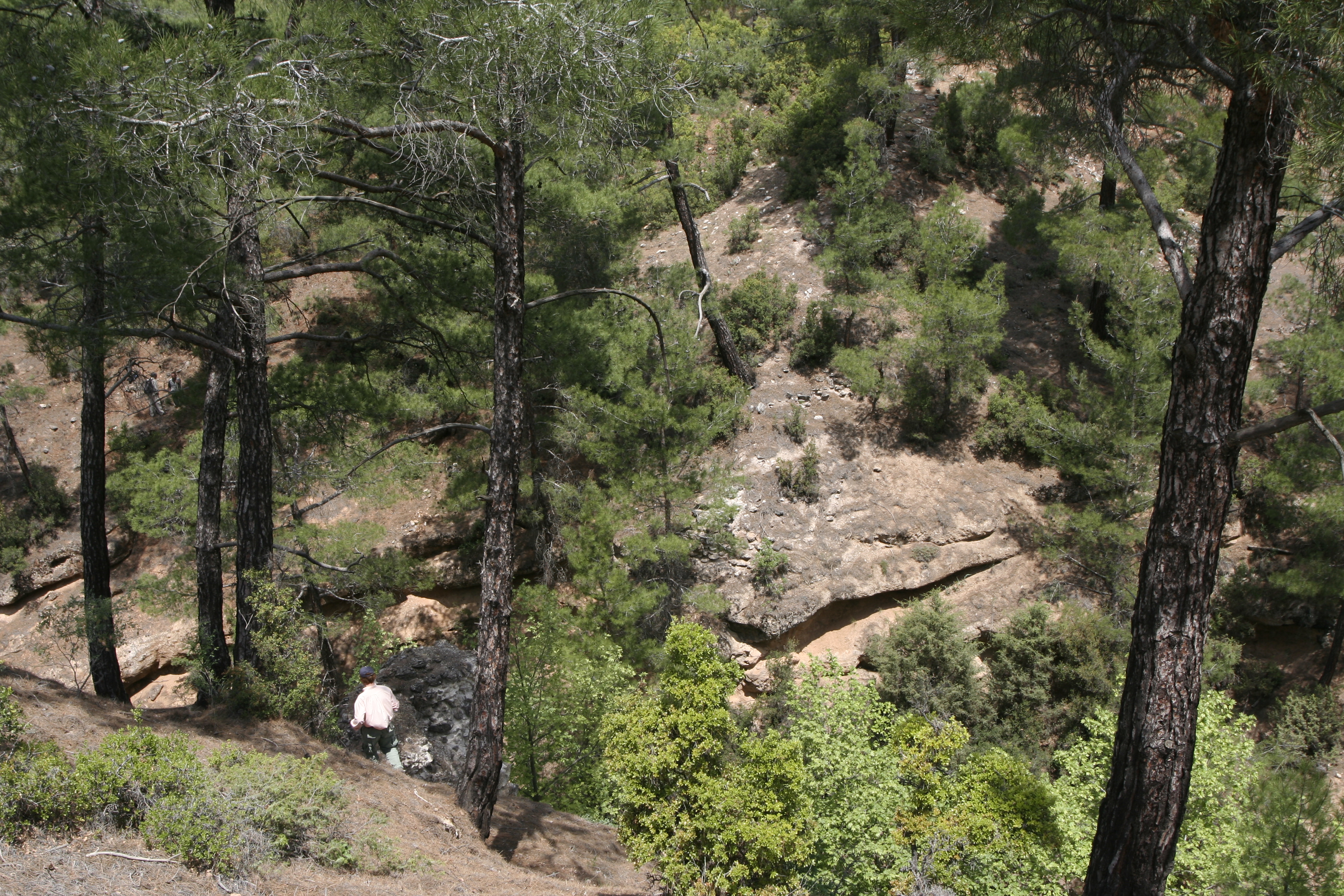
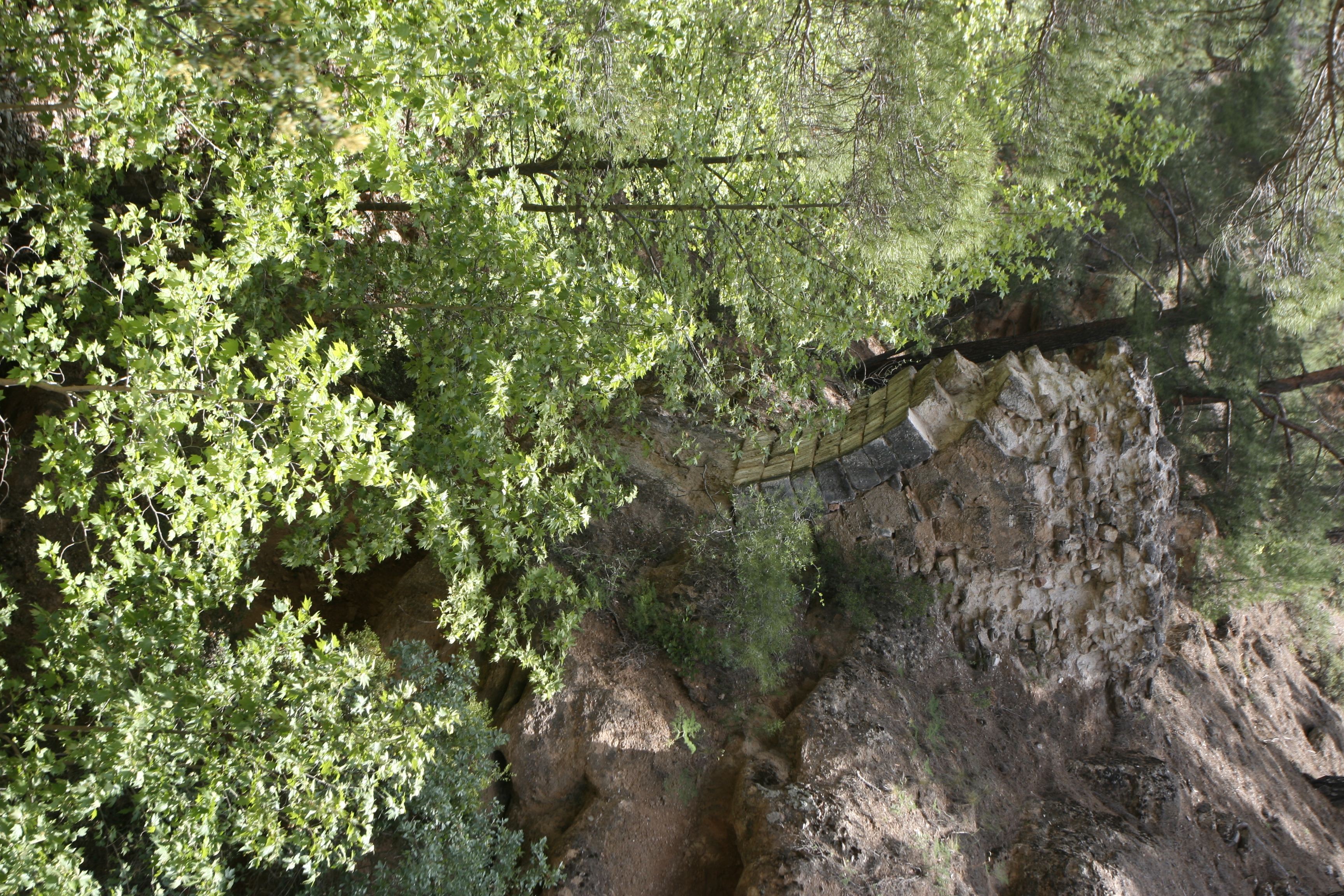
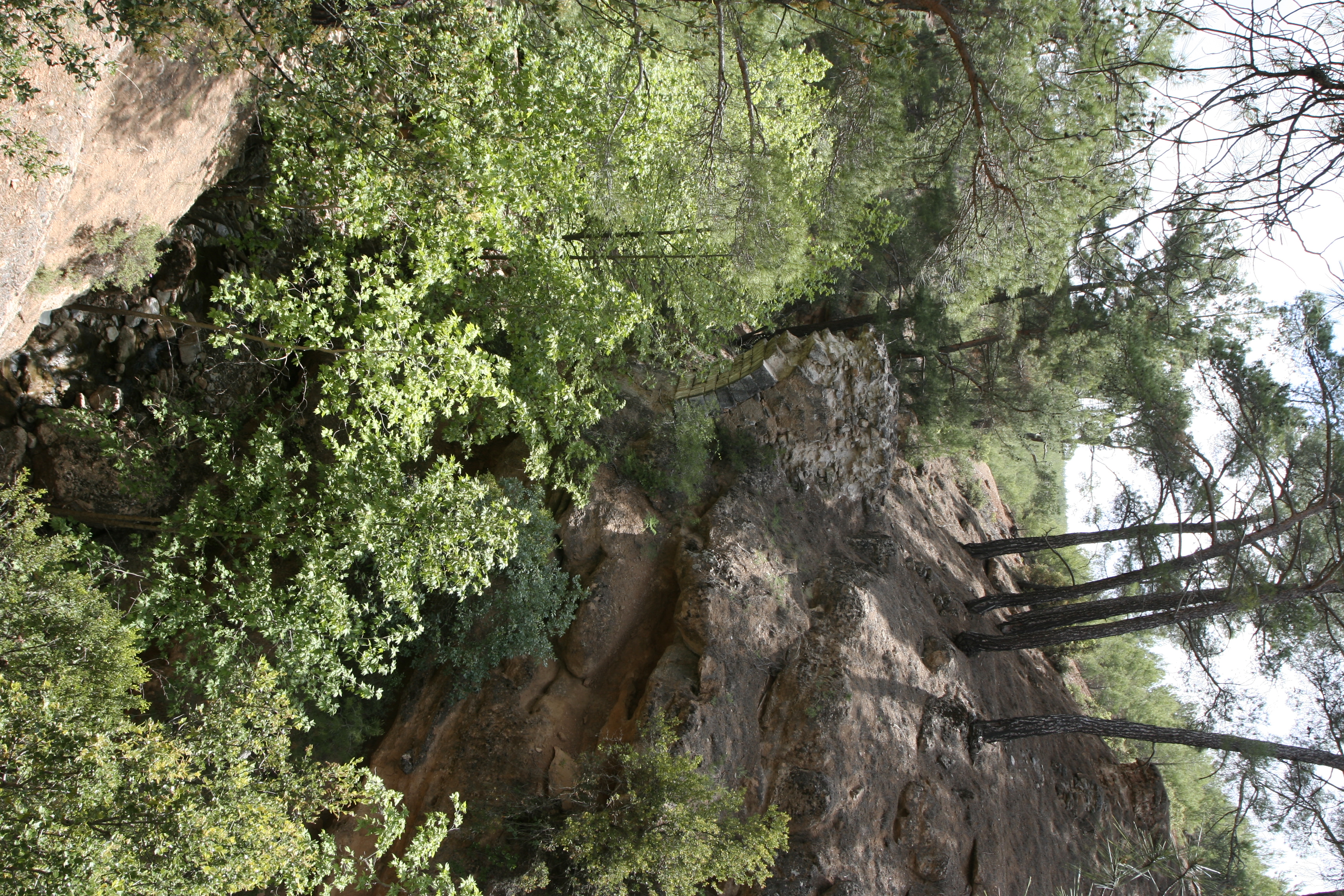
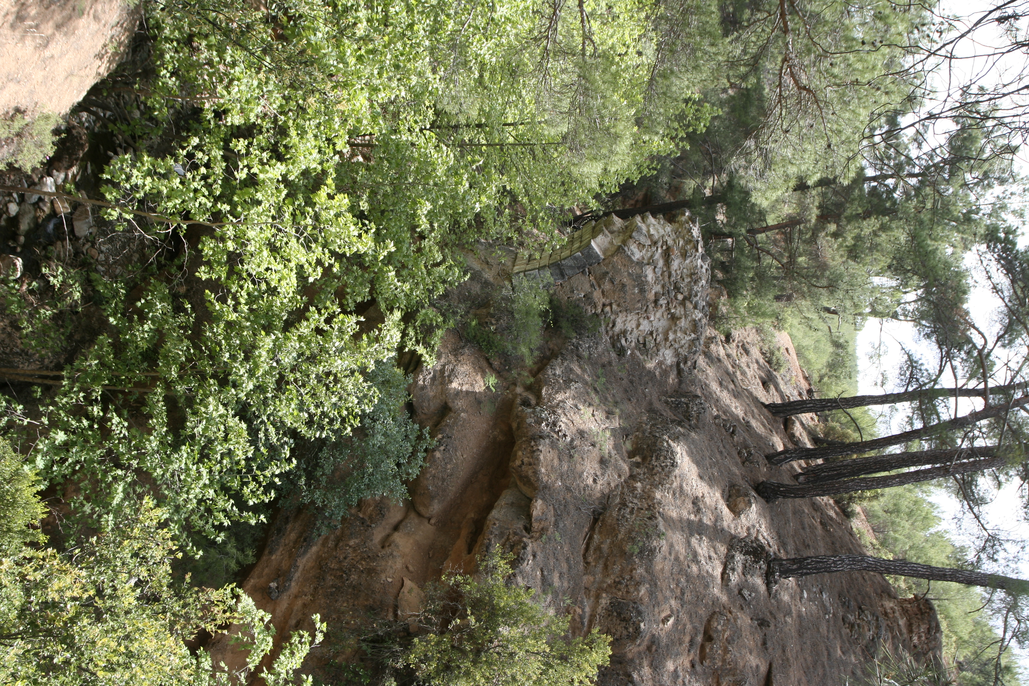
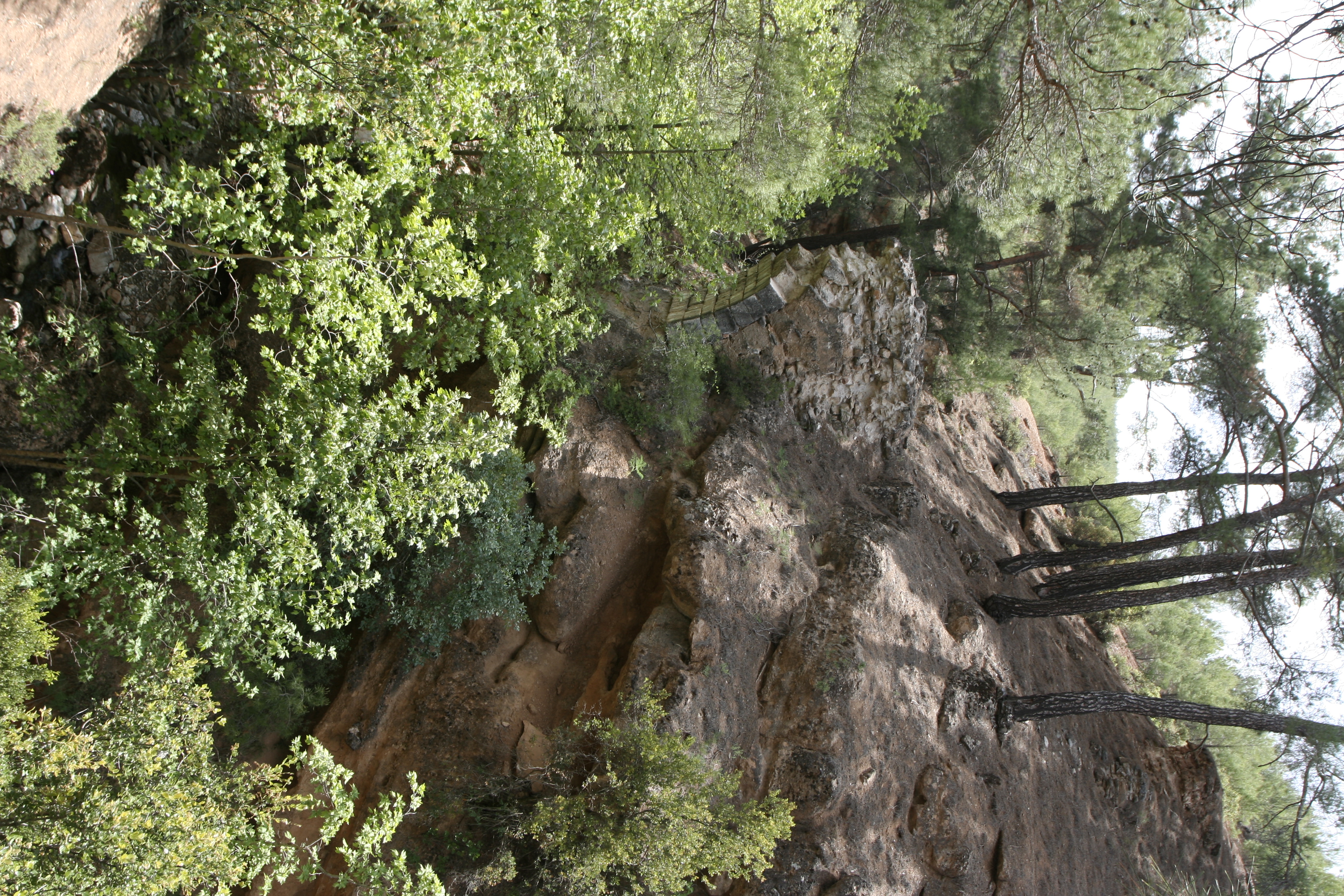
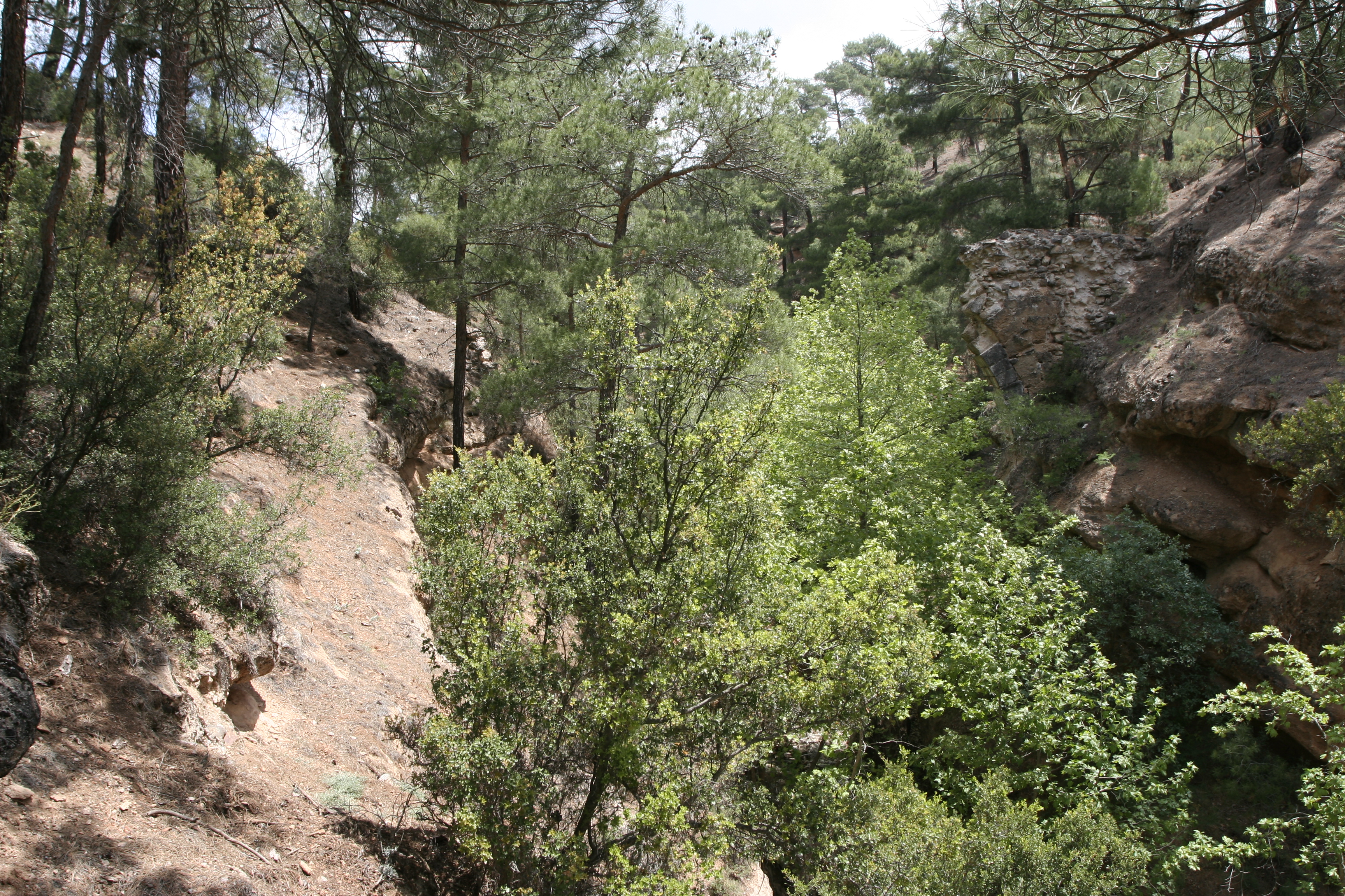
| dc.description | Local Information: Preservation: While nothing remains of the bridge on the north (right) bank of the gorge except weathered mortared rubble and scattered facing blocks, the remains on the south (left) bank are better preserved. These include a portion of the arch of the lower tier of the bridge, remains of the upper tier and buttress, and traces of the conduit. The downstream (west) side of the bridge is better preserved than the upstream side. Fallen voussoirs and large masses of masonry litter the streambed below. ** Construction: The bridge is constructed of mortared rubble faced with petit appareil masonry. The facing blocks and the upper voussoirs of the arch are fashioned from sandy conglomerate rock, while the lower voussoirs are carved from marble. The facing blocks are approximately 0.5 m long and 0.3 m high, while the voussoirs are 0.50 m long, 0.30 m wide, and 0.40–1 m deep. Three types of mortar are visible. Ubiquitous is a white lime mortar with stone inclusions no larger than 0.005 m. Also visible around the crumbling mass of the upper north pier is a light gray lime mortar with larger stone inclusions up to 0.01 m in size. A third type of lime mortar can be found on the buttressed middle mass on the south bank; it has a very loose, pinkish tan matrix with stone inclusions as large as 0.02 m. ** Description: The remains of the bridge suggest that it was originally two-tiered, with a lower arch spanning 13 m and supporting possibly four arches above, each spanning 5.7 m, topped by the conduit. The bridge is preserved to a height of 17 m, a width of 3 m, and a length of 65 m. Traces of the conduit indicate that it was originally 65 m long and 27 m high. The single arch of the lower tier springs from the bedrock of the steep south (left) bank of the gorge at a height of 10 m above the bottom of the gorge. The tier is preserved to a height of 5.5 m. The arch is constructed of two layers of voussoirs. The fallen marble blocks used as voussoirs are variously dressed with anathyrosis, clamp cuttings, lifting bosses, and moldings. The second tier of the bridge begins approximately 4.5 m above the remains of the lower tier. A buttressing structure joins the downstream (west) side of the second tier in a clear seam. Approximately 1 m above the upper tier, the side walls of the conduit are visible. | en_US |
| dc.description | Latitude: 37.36.46.285 | en_US |
| dc.description | Longitude: 28.51.02.578 | en_US |
| dc.description | Elevation: 831 | en_US |
| dc.description | Axis: N-S | en_US |
| dc.description | Dimensions: p. H: 17 m ** p. W (south lower pier): 3 m ** p. L: 65 m ** Projected original H: 27 m ** Projected original L: 65 m ** Projected original H (conduit above streambed): 24.5 m ** Projected original arch span: 13 m (lower tier); 5.7 m (uppertier) ** W (conduit): 1.50 m ** p. H (south lower pier): 5.5 m ** p. H (south upper pier): 4 m ** p. L (south upper pier): 5 m ** Distance (H) between south tower pier and upper pier: 4.5 m ** Distance (H) between south upper pier remains and conduit: 1 m ** p. W (south pier buttress): 1.5 m | en_US |
| dc.description | Description: The remains of the aqueduct bridge indicate that the structure was constructed in two stories of arches in order to maintain the channel elevation across a deep gorge below. On the south bank of the gorge, one segment of the arch (5.5 m. high) springs from the bedrock of the steep hillside, 10 m. above the bottom of the gorge. Only a mortared rubble mass remains of the corresponding pier on the north bank, with no trace of the arch. Approximately 4.5 m. above the arched pier segment on the north bank, another mortared rubble mass is built into the hillside and suggests the use of a second story of arches, none of which now remain. A corresponding section of mortared rubble lies on the north bank. Some kind of buttress or support is built against the west (downstream) side of the remains of the higher story, with a clear seam delineating the two masonry structures. The east (upstream) side of both remaining segments of on the south bank is heavily eroded with lots of missing material and no preserved facing blocks. The buttress on the downstream side must have been built in consideration of the forces such as wind that could potentially jeopardize the stability of the tall structure. The side walls of the aqueduct channel are preserved on the south bank, approximately 1 m. above the preserved level of the second story. The top of the rubble mass on the north bank is at roughly the same elevation as the channel on the south bank, but no traces of the channel are visible here, perhaps due to the construction of a road in this area. ** The few facing blocks of the bridge that remain in situ are located on the west side of the south pier. The blocks are approximately 0.5 m. long and 0.3 m. high and face a mortared rubble core of unworked stones 0.10-.50 m. long. The facing stones appear to be worked from the conglomeratic sandstone bedrock on site, while the rubble core includes stones of various types locally available. Three kinds of mortar are visible in the remaining sections of the structure. Most ubiquitous is a white lime-based mortar with stone inclusions not larger than 5 mm. Also visible around the crumbling mass of the upper north pier is a light gray lime-based mortar with larger stone inclusions, up to 10 mm. A third type of mortar can be found on the buttressed middle mass on the south bank: a very loose pinkish tan matrix with stone inclusions as large as 20 mm. ** The arch is constructed of two levels of voussoirs, the top level carved from the conglomeratic sandstone bedrock and the bottom of marble. Of the nine remaining courses of the lower level of voussoirs, only seven have preserved facing blocks. Three to four voussoirs are preserved in each course, and each is missing at least one more. The voussoir blocks are 0.50 m. long, 0.30 m. wide, and 0.40-1 m. deep. The voussoir blocks seem to be the same width at the extrados and intrados, suggesting that the arch had a considerable span of c. 13 m. A large chunk of mortared rubble, 2.40 m. by 2.70 m., and many single marble blocks litter the stream bed below the structure and for at least 20 m. downstream along the gorge. Many of these fallen marble blocks, which were likely used as voussoirs, are worked in ways that suggest they were originally intended for another purpose. One block, located on the gorge bottom only about a meter downstream from the bridge, is dressed with anathyrosis on one side, two holes on an adjacent side, and a cutting for a butterfly clamp in a recessed corner. Another marble block has a lifting boss and molding along its edges. ** Based on these standing remains, the bridge has been theoretically reconstructed with a lower arch spanning the gorge across 13 m., topped by a second story of four arches, centered on the lower arch and each spanning 5.75 m. Attempt has not been made to reconstruct the buttressing structure on the downstream (west) side of the bridge. | en_US |
| dc.subject | Waterworks | en_US |
| dc.subject | 4: Roman | en_US |
| dc.title | E008: Timeles Aqueduct, Harami Deresi Bridge | en_US |
| dc.type | Other | en_US |
| dc.subject.hlbsecondlevel | Archaeology | en_US |
| dc.subject.hlbtoplevel | Social Sciences | en_US |
| dc.description.bitstreamurl | http://deepblue.lib.umich.edu/bitstream/2027.42/92938/1/D2007.0460.JPG | |
| dc.description.bitstreamurl | http://deepblue.lib.umich.edu/bitstream/2027.42/92938/2/D2007.0461.JPG | |
| dc.description.bitstreamurl | http://deepblue.lib.umich.edu/bitstream/2027.42/92938/3/D2007.0462.JPG | |
| dc.description.bitstreamurl | http://deepblue.lib.umich.edu/bitstream/2027.42/92938/4/D2007.0463.JPG | |
| dc.description.bitstreamurl | http://deepblue.lib.umich.edu/bitstream/2027.42/92938/5/D2007.0464.JPG | |
| dc.description.bitstreamurl | http://deepblue.lib.umich.edu/bitstream/2027.42/92938/6/D2007.0465.JPG | |
| dc.description.bitstreamurl | http://deepblue.lib.umich.edu/bitstream/2027.42/92938/7/D2007.0466.JPG | |
| dc.description.bitstreamurl | http://deepblue.lib.umich.edu/bitstream/2027.42/92938/8/D2007.0467.JPG | |
| dc.description.bitstreamurl | http://deepblue.lib.umich.edu/bitstream/2027.42/92938/9/D2007.0468.JPG | |
| dc.description.bitstreamurl | http://deepblue.lib.umich.edu/bitstream/2027.42/92938/10/D2007.0469.JPG | |
| dc.description.bitstreamurl | http://deepblue.lib.umich.edu/bitstream/2027.42/92938/11/RS24.JPG | |
| dc.owningcollname | Aphrodisias Regional Survey |
Files in this item
Remediation of Harmful Language
The University of Michigan Library aims to describe library materials in a way that respects the people and communities who create, use, and are represented in our collections. Report harmful or offensive language in catalog records, finding aids, or elsewhere in our collections anonymously through our metadata feedback form. More information at Remediation of Harmful Language.
Accessibility
If you are unable to use this file in its current format, please select the Contact Us link and we can modify it to make it more accessible to you.