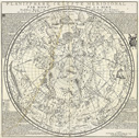
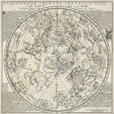
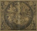
Celestial MapsWhile maps of the stars are almost as old as stargazing itself, nearly all of the constellations through which the Western world has come to view the heavens can be traced back to the star catalog included in Ptolemy’s Almagest, written around 150 A.D., which included 1,028 stars grouped into 48 constellations and which influenced celestial cartography for the next fourteen centuries.1 Although Ptolemy relied on ancient tradition to supply the figures for his constellations, the stature of his Almagest was such that the ancient constellations would thereafter be known as Ptolemaic, relegating those invented later to the category of non-Ptolemaic constellations. These eventually became so numerous that in 1922 the International Astronomical Union was compelled to create a standardized set of 88 “official” constellations. For modern viewers the mythological figures that populate these maps are evocative not only of the ancient world that originated them, but also of more recent times when the universe felt smaller and the skies were filled with familiar characters — a stark contrast to what modern science teaches us, that we are infinitesimal specks floating in a vast and directionless void. The story of the star map’s evolution from fanciful vehicle for myth and legend to utilitarian instrument used in navigation and scientific discourse is one that has been told by many authors. Patricia Burnham eloquently describes the star map’s loss of humanity in the face of an ever burgeoning catalog of stellar objects: As with illustrations of planetary systems, star charts ceased to be works of art treasured by a literate public and became functional instruments used by specialists. The transformation of constellation figures to dots on computer printouts denotes the atomization of humankind; the heavens are no longer anthropomorphic images but depersonalized areas in the sky.2 Yet it is also important to remember that constellation figures served a purpose and were not valued for their artistic qualities only. As Deborah Jean Warner suggests in her essay from the same volume, the narrative presented by Burnham tells only one side of the story: Contemporary astronomers in well-equipped observatories can locate any celestial object from its coordinates and, conversely, they can easily determine the coordinates of newly discovered objects. Throughout most of history, however, people used constellations to find their way through the heavens, and they located new objects by measuring their distances from stars that were already charted. Thus for them star charts were indispensable tools, enjoyed for their beauty but depended on for their accuracy.3 The reality is more complex than either of these two opposing narratives suggest. As in so many other areas of human endeavor, the artistic and technical development of star maps have been driven mutually by each other. It is only fair to represent their history from both angles, which is what we have tried to do in this section of the exhibit. The two celestial planispheres by Phillipe de La Hire illustrate the value of star maps as utilitarian objects, as they were included in a number of popular atlases throughout the eighteenth century. The Cellarius print has a unique and interesting history which illustrates the cultural and artistic values placed on celestial maps by certain segments of our society. For more celestial maps, see the Atlases & Charts section of the exhibit. 1 Warner 2005 17. 2 Burnham 15. 3 Warner 2005 17. |


