 Access by request
A063: Seki Aqueduct, Yüksekkemersi Dere Bridge
| dc.contributor.author | Aphrodisias Regional Survey | en_US |
| dc.date.accessioned | 2012-08-24T19:01:13Z | |
| dc.date.available | 2012-08-24T19:01:13Z | |
| dc.date.issued | 2005-06-09 | en_US |
| dc.identifier.citation | Page reference: Christopher Ratté and Peter D. De Staebler (eds.). Aphrodisias V. The Aphrodisias Regional Survey (Verlag Philipp von Zabern: Darmstadt/Mainz, 2012), 243, 245, 295 - Book catalogue no.: Aqueducts cat. 1. <http://hdl.handle.net/2027.42/93089> | en_US |
| dc.identifier.other | A063 | en_US |
| dc.identifier.uri | https://hdl.handle.net/2027.42/93089 | |
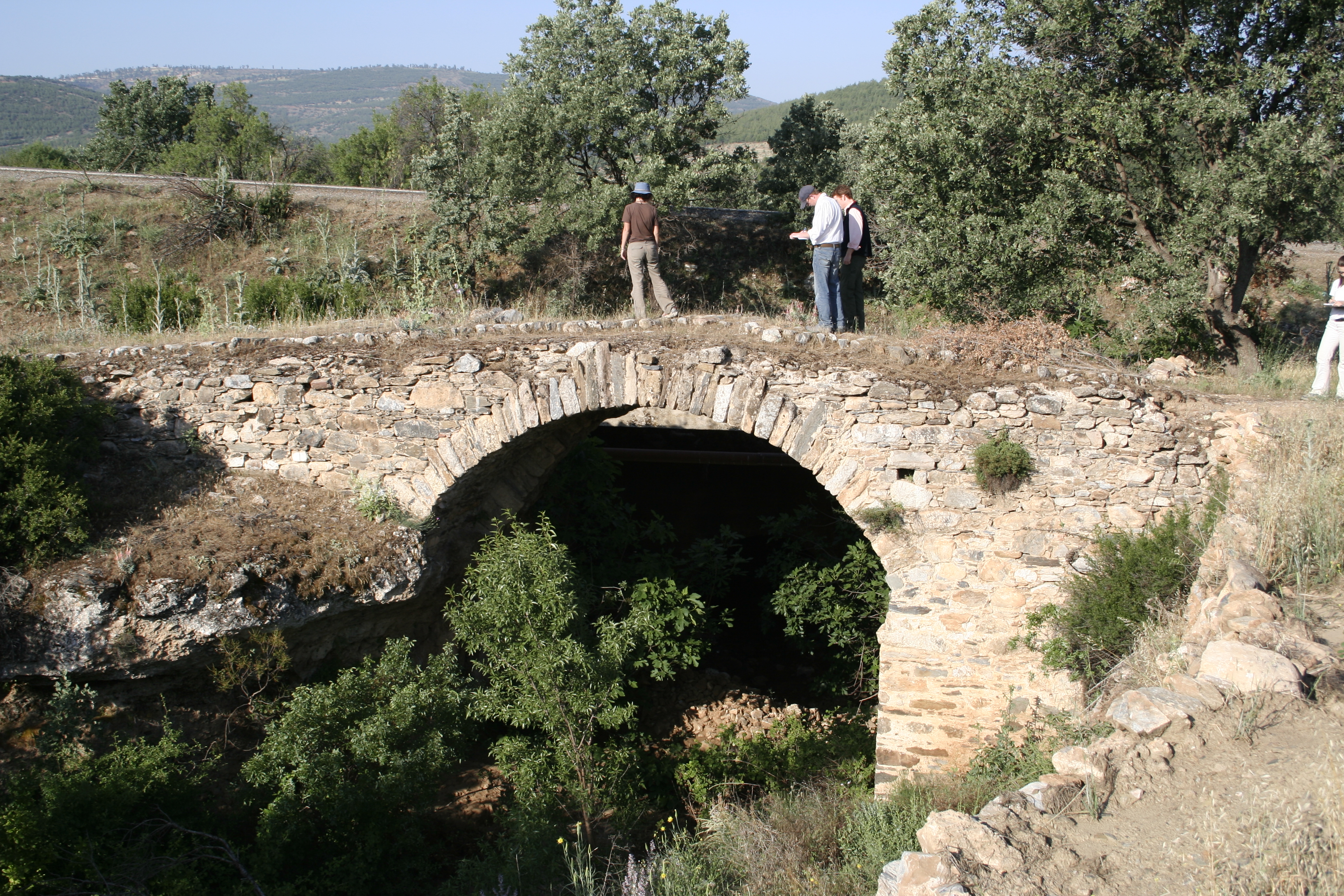
| dc.description | Local Name: Seki | en_US |
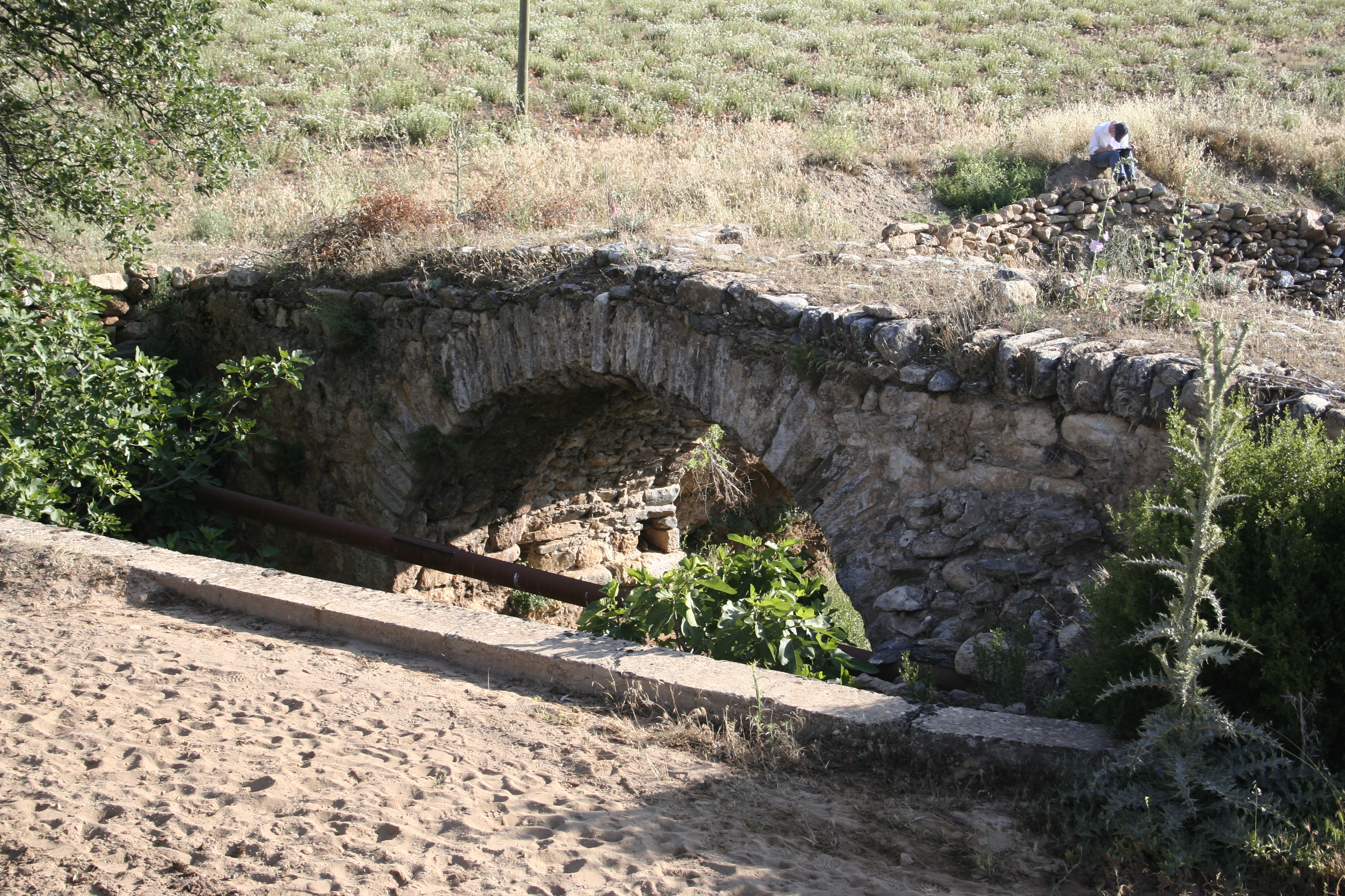
| dc.description | Local Information: The bridge crosses the Yüksekkemer Deresi, a tributary of the Morsynus river. It is located 8.5 km southeast of Aphrodisias and 1.5 km southeast of the modern village of Seki, just northeast of the main road running through the valley. | en_US |
| dc.description | Latitude: 37.41.15.96 | en_US |
| dc.description | Longitude: 28.48.56.10 | en_US |
| dc.description | Elevation: 705m | en_US |
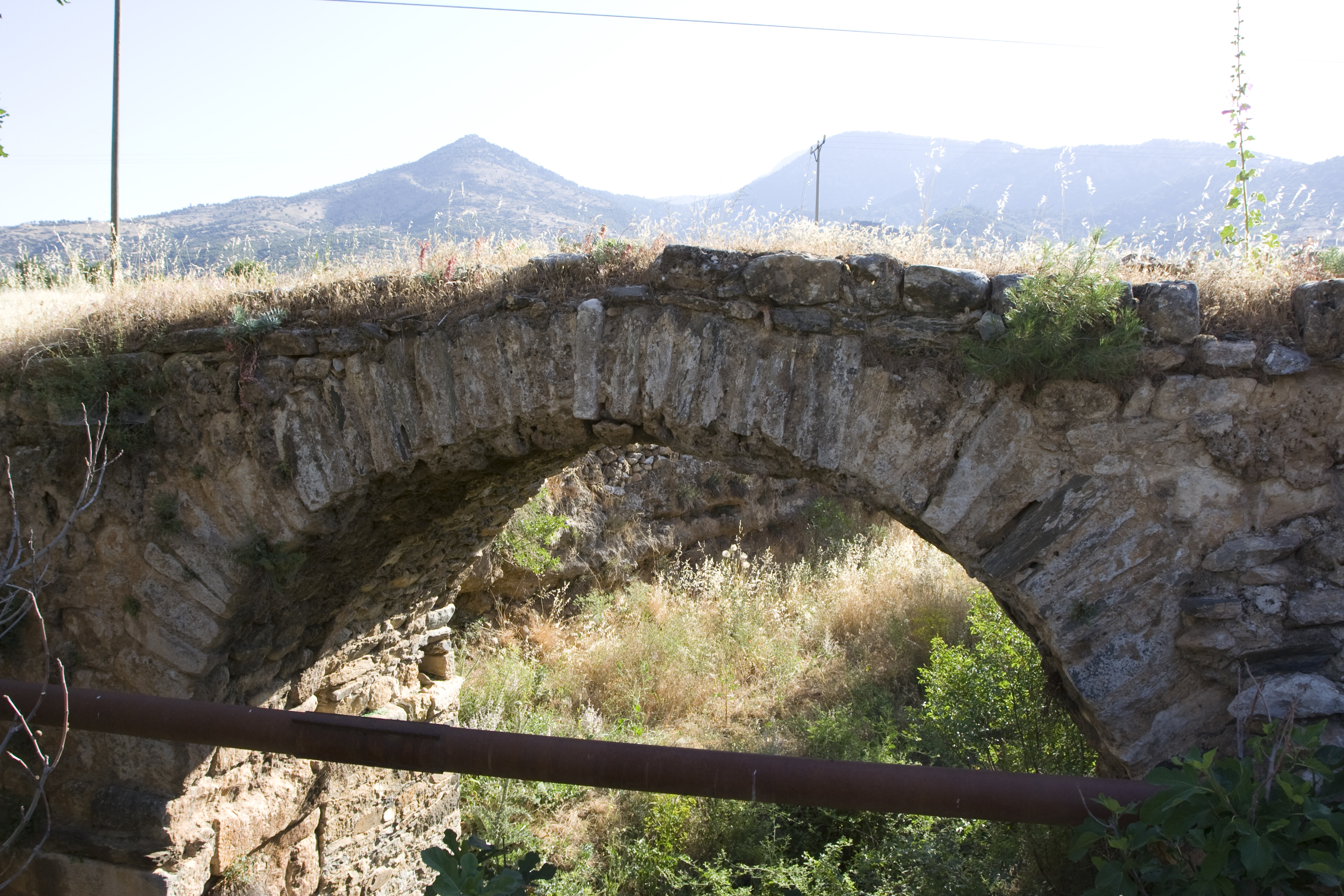
| dc.description | Dimensions: p. H: 6 m ** W (northwest pier): 1.7 m ** p. L: 15 m ** Arch span: 5 m ** H (ground to bottom of projecting course): 2.5 m ** H (streambed to bottom of arch): 5.9 m | en_US |
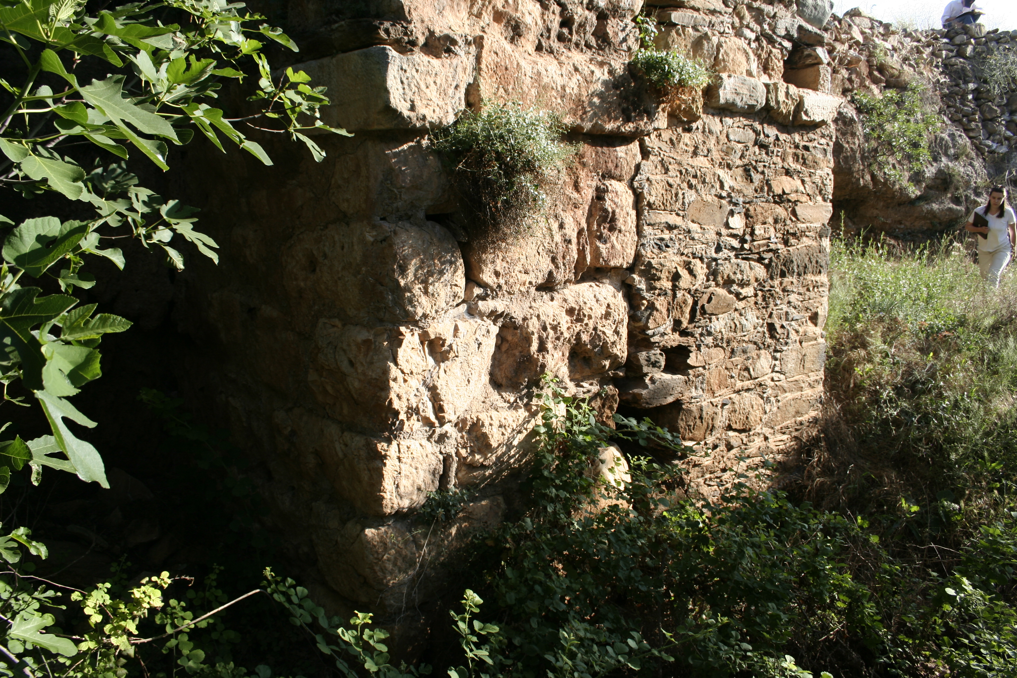
| dc.description | Description: Preservation: The piers and arch of the bridge are well preserved because they were incorporated into a later (probably Ottoman) road bridge. However, the composite structure was leveled and resurfaced at that time, so the masonry above the arch and the conduit are not preserved at all. The southeast pier is covered with calcium carbonate incrustations. ** Construction: The bridge is constructed of mortared rubble faced with petit appareil masonry. The facing blocks and voussoirs include fieldstones of quartz and sandstone, as well as larger blocks of marble, some originally dressed for other purposes. The facing blocks are 0.30–0.40 m long and 0.15–0.20 m high; the blocks above the projecting course of the northwest pier are smaller than those below. The blocks of the projecting course are up to 1.20 m long and 0.30 m high. The voussoirs range in size from 0.30 to 0.50 m long and 0.15 to 0.20 m wide at the extrados. The lime mortar is pale beige with stone inclusions, most no larger than 0.05 m, while a hard blue mortarlike material covers the joins between the large blocks of the base of the northwest pier. ** Description: The Roman bridge is preserved to a height of 6 m, a width of 1.7 m, and a length of 15 m. Large blocks form the base of the northwest pier, founded within the soil of the stream bank. A projecting course is visible only on the northwest pier, 2.5 m above the ground. The arch springs from a point two courses higher than the projecting course and spans 5 m. ** The Ottoman bridge is built against the northeast side of the aqueduct bridge. It is constructed of mortared rubble faced with petit appareil masonry, but the facing blocks are smaller and more varied in size (with a maximum length of 0.60 m) than those of the aqueduct bridge, and chinking stones are used more liberally. The bridge is 1.8 m wide and has a projecting course that does not span the entire width of its northwest pier because it is built in line with the projecting course of the Roman aqueduct bridge. The arch has a slightly greater span than the arch of the aqueduct bridge, and putlog holes are visible under the arch directly above the projecting course and in the southwest corner of the base of the pier. | en_US |
| dc.subject | Waterworks | en_US |
| dc.subject | 4: Roman | en_US |
| dc.subject | 5: Late Roman | en_US |
| dc.subject | 6: Byzantine | en_US |
| dc.subject | 8: Modern | en_US |
| dc.subject | 7: Ottoman | en_US |
| dc.title | A063: Seki Aqueduct, Yüksekkemersi Dere Bridge | en_US |
| dc.type | Other | en_US |
| dc.subject.hlbsecondlevel | Archaeology | en_US |
| dc.subject.hlbtoplevel | Social Sciences | en_US |
| dc.description.bitstreamurl | http://deepblue.lib.umich.edu/bitstream/2027.42/93089/1/D2005.0469.JPG | |
| dc.description.bitstreamurl | http://deepblue.lib.umich.edu/bitstream/2027.42/93089/2/D2005.0470.JPG | |
| dc.description.bitstreamurl | http://deepblue.lib.umich.edu/bitstream/2027.42/93089/3/D2005.0471.JPG | |
| dc.description.bitstreamurl | http://deepblue.lib.umich.edu/bitstream/2027.42/93089/4/D2005.0472.JPG | |
| dc.description.bitstreamurl | http://deepblue.lib.umich.edu/bitstream/2027.42/93089/5/D2005.0473.JPG | |
| dc.description.bitstreamurl | http://deepblue.lib.umich.edu/bitstream/2027.42/93089/6/D2005.0474.JPG | |
| dc.description.bitstreamurl | http://deepblue.lib.umich.edu/bitstream/2027.42/93089/7/D2005.0475.JPG | |
| dc.description.bitstreamurl | http://deepblue.lib.umich.edu/bitstream/2027.42/93089/8/D2008.1312.JPG | |
| dc.description.bitstreamurl | http://deepblue.lib.umich.edu/bitstream/2027.42/93089/9/D2008.1313.JPG | |
| dc.description.bitstreamurl | http://deepblue.lib.umich.edu/bitstream/2027.42/93089/10/D2008.1314.JPG | |
| dc.description.bitstreamurl | http://deepblue.lib.umich.edu/bitstream/2027.42/93089/11/D2008.1315.JPG | |
| dc.description.bitstreamurl | http://deepblue.lib.umich.edu/bitstream/2027.42/93089/12/D2008.1316.JPG | |
| dc.description.bitstreamurl | http://deepblue.lib.umich.edu/bitstream/2027.42/93089/13/RS28.JPG | |
| dc.owningcollname | Aphrodisias Regional Survey |
Files in this item
Remediation of Harmful Language
The University of Michigan Library aims to describe library materials in a way that respects the people and communities who create, use, and are represented in our collections. Report harmful or offensive language in catalog records, finding aids, or elsewhere in our collections anonymously through our metadata feedback form. More information at Remediation of Harmful Language.
Accessibility
If you are unable to use this file in its current format, please select the Contact Us link and we can modify it to make it more accessible to you.