 Access by request
A040: Tantalus Citadel
| dc.contributor.author | Aphrodisias Regional Survey | en_US |
| dc.date.accessioned | 2012-08-24T19:04:56Z | |
| dc.date.available | 2012-08-24T19:04:56Z | |
| dc.date.issued | 2005-06-05 | en_US |
| dc.identifier.citation | Page reference: Christopher Ratté and Peter D. De Staebler (eds.). Aphrodisias V. The Aphrodisias Regional Survey (Verlag Philipp von Zabern: Darmstadt/Mainz, 2012), 4, 8, 14, 15, 37. <http://hdl.handle.net/2027.42/93156> | en_US |
| dc.identifier.other | A040 | en_US |
| dc.identifier.uri | https://hdl.handle.net/2027.42/93156 | |
| dc.description | Local Name: Dandalaz | en_US |
| dc.description | Local Information: The river had cut through the spur that juts out on the NE side and had formed a natural bridge. It was possible to walk up the slope along the knife edge. The new land owner recently cut through and destroyed the natural bridge, however, in order to stop local children from climbing on it. | en_US |
| dc.description | Latitude: 37.43.46.08 | en_US |
| dc.description | Longitude: 28.38.14.16 | en_US |
| dc.description | Elevation: 403m | en_US |
| dc.description | Dimensions: approximately 90m (N-S) by 53m (E-W) | en_US |
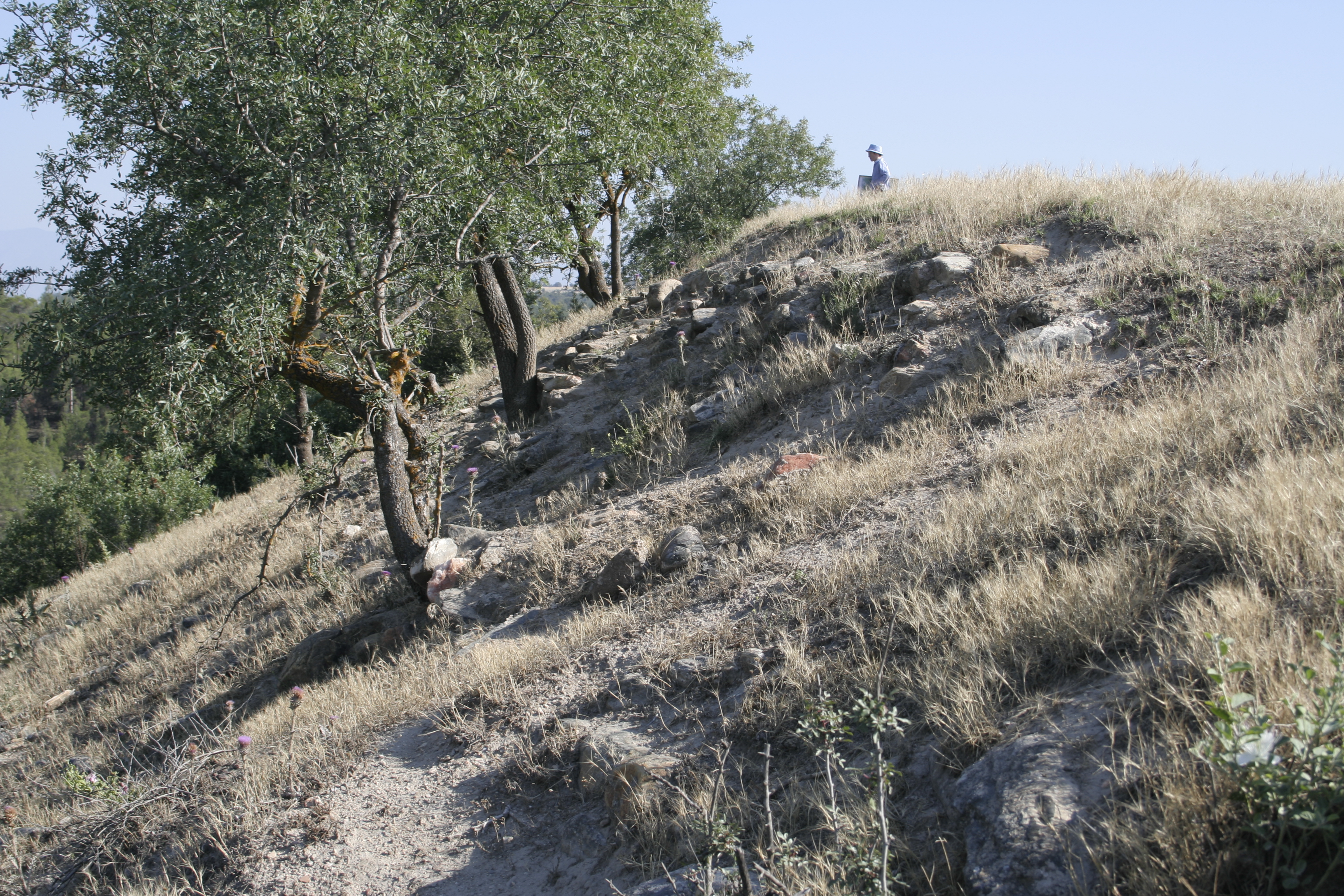
| dc.description | Description: Just upstream of the Ottoman bridge over the limestone gorge formed by the Morsynus river is a distinctive flat-topped hill, crowned by the remains of a Byzantine citadel, probably Medieval Tantalus, after which the river and the settlement at the bridge takes its modern name of Dandalaz. ** The name is recorded as part of an account of an army passing through the Morsynus river valley by the Byzantine historian Niketas Choniates ('Historia' 654–55) that describes of the campaign of the Sultan of Iconium, Kaykhusraw I, in ca. AD 1200 against Antioch on the Maeander. On the way to Antioch (moving apparently from east to west), Kaykhusraw first attacked Caria, apparently Aphrodisias, and then Tantalus (see also Roueché, eALA, VII.27.). Both places were captured and their combined populations of 5,000 deported to Philomelium, modern Akşehir, 250 km away. ** The hill, isolated in a curve in teh changing course of the river, is natural, and the south and west sides are almost sheer cliffs, The flatness of the top may be caused by the remains of the surrounding fortifications. The remains of various structures are visible on the surface, and traces of casemate walls are seen at places on the lower north and east slopes. The structrues are built from uncoursed rubble, held together with white mortar. The structures contain assorted reused blocks. The casemate chambers are approximately 1.78m thick, and the wall itself approximately 5m thick. ** Few coarse pottery fragments are seen on the surface, especially on the NE slope, together with bricks and tiles with quartz and schist inclusions. | en_US |
| dc.description | Finds: Pottery and tile sherds ** Rim of bowl with pinched edge and rope decoration. | en_US |
| dc.subject | Citadels and Watchtowers | en_US |
| dc.subject | 6: Byzantine | en_US |
| dc.title | A040: Tantalus Citadel | en_US |
| dc.type | Other | en_US |
| dc.subject.hlbsecondlevel | Archaeology | en_US |
| dc.subject.hlbtoplevel | Social Sciences | en_US |
| dc.description.bitstreamurl | http://deepblue.lib.umich.edu/bitstream/2027.42/93156/1/D2005.0273.JPG | |
| dc.description.bitstreamurl | http://deepblue.lib.umich.edu/bitstream/2027.42/93156/2/D2005.0274.JPG | |
| dc.description.bitstreamurl | http://deepblue.lib.umich.edu/bitstream/2027.42/93156/3/D2005.0275.JPG | |
| dc.description.bitstreamurl | http://deepblue.lib.umich.edu/bitstream/2027.42/93156/4/D2005.0276.JPG | |
| dc.description.bitstreamurl | http://deepblue.lib.umich.edu/bitstream/2027.42/93156/5/D2005.0277.JPG | |
| dc.description.bitstreamurl | http://deepblue.lib.umich.edu/bitstream/2027.42/93156/6/D2005.0278.JPG | |
| dc.description.bitstreamurl | http://deepblue.lib.umich.edu/bitstream/2027.42/93156/7/D2005.0279.JPG | |
| dc.description.bitstreamurl | http://deepblue.lib.umich.edu/bitstream/2027.42/93156/8/D2005.0280.JPG | |
| dc.description.bitstreamurl | http://deepblue.lib.umich.edu/bitstream/2027.42/93156/9/D2005.0281.JPG | |
| dc.description.bitstreamurl | http://deepblue.lib.umich.edu/bitstream/2027.42/93156/10/D2005.0282.JPG | |
| dc.description.bitstreamurl | http://deepblue.lib.umich.edu/bitstream/2027.42/93156/11/D2005.0283.JPG | |
| dc.description.bitstreamurl | http://deepblue.lib.umich.edu/bitstream/2027.42/93156/12/D2005.0284.JPG | |
| dc.description.bitstreamurl | http://deepblue.lib.umich.edu/bitstream/2027.42/93156/13/D2005.0285.JPG | |
| dc.description.bitstreamurl | http://deepblue.lib.umich.edu/bitstream/2027.42/93156/14/D2005.0286.JPG | |
| dc.description.bitstreamurl | http://deepblue.lib.umich.edu/bitstream/2027.42/93156/15/D2005.0287.JPG | |
| dc.description.bitstreamurl | http://deepblue.lib.umich.edu/bitstream/2027.42/93156/16/D2005.0288.JPG | |
| dc.owningcollname | Aphrodisias Regional Survey |
Files in this item
Remediation of Harmful Language
The University of Michigan Library aims to describe library materials in a way that respects the people and communities who create, use, and are represented in our collections. Report harmful or offensive language in catalog records, finding aids, or elsewhere in our collections anonymously through our metadata feedback form. More information at Remediation of Harmful Language.
Accessibility
If you are unable to use this file in its current format, please select the Contact Us link and we can modify it to make it more accessible to you.