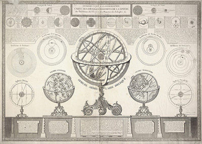
Introduction a la gographie, Carte des diverses positions de la sphere, des systhmes de lUnivers, des planettes des eclypses &. / par le Sr. Delafosse Gographe.
Detached from: Didier Robert de Vaugondy. Atlas dtude.
Chatry de La Fosse
Paris: C.F. Delamarche, 1797-[1798]
Engraving
From the collection of the University of Michigan Map Library
This map shows a trio of celestial, terrestrial, and armillary spheres accompanied by four diagrams that illustrate the systems of Ptolemy, Copernicus, Brahe and Descartes. The two diagrams flanking the cartouche demonstrate the mechanics of solar and lunar eclipses, and there are twelve smaller inset illustrations of the planets.
The map is detached from the Atlas dtude of Didier Robert de Vaugondy (1723-1786), a French cartographer and maker of globes who also published some celestial hemispheres during the late 18th century.1 Little is known about de La Fosse, but his map merits inclusion for its quite literal depiction of the heavens as mechanical devices, a hallmark of the mechanism that pervaded 18th century scientific thought.
The visual trope of the three mechanical spheres — a large armillary sphere flanked by smaller celestial and terrestrial globes — most likely originated with a print entitled La Sphere Artificielle that was published in Nicolas de Fer’s 1703 L’Atlas Curieux, a popular work that went through several editions and was widely imitated.2
1 Kanas 350.
2 Kanas 215.


